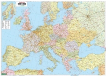
Image for Political Europe, wall map 1:2,600,000, magnetic marking board, freytag & berndt

Political Europe, wall map 1:2,600,000, magnetic marking board, freytag & berndt

See all formats and editions

The political wall map of Europe 1:2,600,000 offers a good overview of the countries of Europe.

In addition to the highways and main traffic routes, it shows large cities, important places, rivers and lakes.

Distances are shown in kilometers. The countries are shown in multiple colors to make them easier to distinguish. The wall map is laminated to a very light but stable plastic plate, covered with a UV-resistant magnetic film and framed with a silver-coated aluminum frame. Magnetic marking board Europe 1:2,600,000MagneticCan be written on and wiped cleanPlaces can be marked with marking needles and pinsThe hanging device is not visibleLarge format: approx. 172 x 123 cmThe weight: approx. 6 kg

Read More
Available
£263.92 Save 20.00%
RRP £329.90
Add Line Customisation
Usually dispatched within 4 weeks
Add to List
Product Details
Freytag-Berndt
370790850X / 9783707908503
Sheet map, folded
16/08/2016
Austria
General (US: Trade) Learn More